McCormick Creek wildfire increases in size, 50 percent contained

By Nelson Daily Staff
The Regional District of Central Kootenay Emergency Operations Centre said in a media release that BC Wildfire Service reports that the McCormick Creek wildfire has grown to 410 hectares in size and is at a 50 percent containment level.
“Currently, there is a crew of 54 firefighters, four helicopters and 13 pieces of heavy equipment on site,” the release said.
“The contingency dozer line has been completed and currently crews are able to work directly on the fire.”
BC Wildfire Service said this widfire has not crossed the highway or impacted any structures.
The RDCK Evacuation Order and Evacuation Alert remain in place for that area.
Visit the RDCK Evacuation Info Page for up to date information.
The news comes after the BC Wildfire Service send out a reminder to the public that they must stay clear of firefighting aircraft that are collecting water from lakes and other bodies of water.
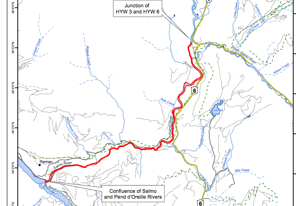
“Effective Aug. 16, 2017, an area restriction is in effect for the Salmo River between the point where it joins the Pend d’Oreille River and the point of the river nearest the junction of Highway 3 and Highway 6,” the BC Wildfire Service said.
“This area restriction means that no people or watercraft are allowed to be on that section of the Salmo River at any time.”
A map of the affected area is available online at http://ow.ly/uCQh30esKRm
BC Wildfire Service said the Pend d’Oreille River currently does not have an area restriction in place.
“That could change if recreational boaters there interfere with fire suppression activities. Conservation officers will continue to patrol these two rivers to ensure compliance.”
BC Wildfire Service said when firefighting aircraft, such as airtankers or helicopters, are working on an active wildfire and picking up water, they need plenty of room to manoeuvre to do their job safely.
“Recreational boaters or people using other watercraft who try to get a close-up look at these aircraft present a serious safety risk for air crews and anyone else in the area,” the BC Wildfire Service said.
“This behaviour is extremely dangerous and interferes with the BC Wildfire Service’s ability to fight a fire, since a pilot cannot collect water when a boat is in its intended flight path.”
In addition, BC Wildfire Service said there are danger trees (trees that have been damaged by fire to the point where they may be unstable) along the banks of these two rivers, which present a potential threat to the safety of anyone travelling in those areas.
Reports of boaters getting in the way of an airtanker, helicopter or other firefighting aircraft will be investigated by Compliance and Enforcement Branch, the Conservation Officer Service and/or the RCMP.
- Under the Wildfire Act, the person responsible could face a violation ticket fine of $1,150.
- There is also an option to levy an administrative penalty instead of a violation ticket. The maximum penalty is $100,000 under the Wildfire Regulation.
- The person could also be charged with an offence under Section 43(3) of the Wildfire Act, which carries a maximum fine of $100,000.
The Southeast Fire Centre extends from the U.S. border in the south to the Mica Dam in the north and from the Okanagan Highlands and Monashee Mountains in the west to the B.C.-Alberta border in the east. The Southeast Fire Centre includes the Selkirk Natural Resource District and the Rocky Mountain Natural Resource District.
To report a wildfire or open burning violation, call *5555 on a cellphone or 1 800 663-5555 toll-free. For the latest information on current wildfire activity, burning restrictions, road closures and air quality advisories, visit: www.bcwildfire.ca


Comments