Active Peace Valley landslide renews questions about slope stability and BC government secrecy
By Sarah Cox, for The Narwhal
For the second time in 20 months, residents of Old Fort are dealing with a large landslide that has cut off road access to the community, prompting calls for more transparency from the provincial government which continues to investigate a 2018 landslide in the same location.
As an active new landslide severs the only road to the Peace Valley community of Old Fort, residents want to know why the B.C. government is refusing to release information about an earlier landslide in the same location, near the Site C dam construction site.
“What kind of information do you have that is so bad that you can’t share it?” asked Kali Chmelyk, one of 150 Old Fort residents who has been under an evacuation alert since June 19, shortly after residents first noticed cracks and buckling in the road following a heavy rainfall.
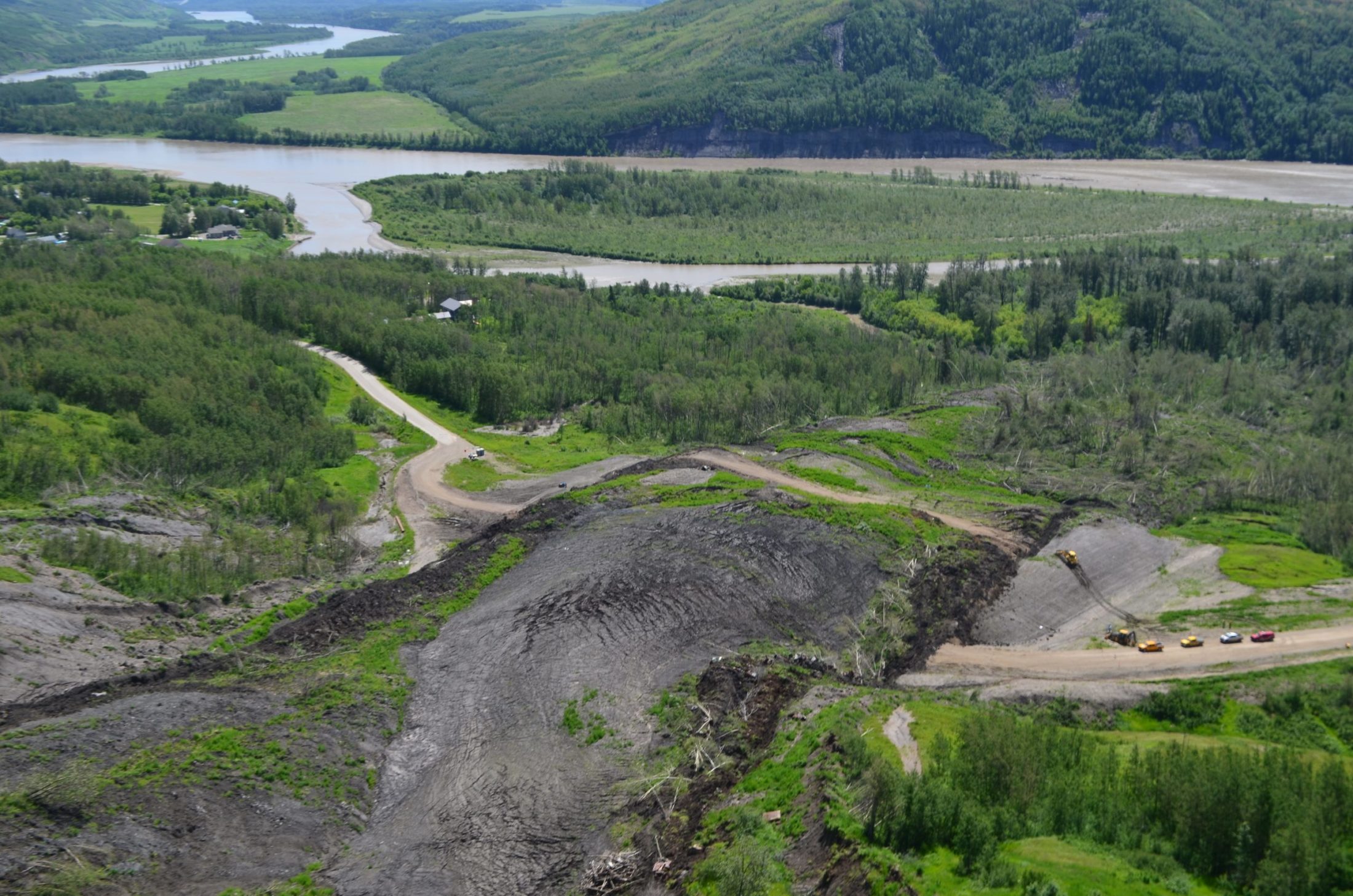
Since then, an advancing wall of mud has eliminated more than 150 metres of the Old Fort access road, which was rebuilt after an October 2018 landslide wiped out part of the road, destroyed a home and prompted a local state of emergency.
The new slide has picked up speed and has been moving towards the Peace River at approximately two metres per hour since 10 p.m. on June 21, according to the B.C. Ministry of Transportation and Infrastructure.
“It seems really shady,” Chmelyk said. “If we could at least know what’s going on, see the report, even if it’s a draft, that’s all I want. I don’t get it. I don’t understand why they would be withholding that.”
Last year, The Narwhal learned through a Freedom of Information request that the 2018 landslide, in an area underlaid by numerous natural gas leases and near one entrance to the Site C dam worksite, was classified as a “dangerous occurrence” under B.C.’s health, safety and reclamation code.
That triggered a geotechnical assessment to identify “the root cause and contributing factors” of the slide, according to a briefing note for Peter Robb, mining and energy assistant deputy minister.
In November 2019, the ministry told The Narwhal the assessment was not yet complete.
The Peace River Regional District subsequently filed a Freedom of Information request seeking all reports related to the landslide, which displaced eight million cubic metres of earth, cutting off Old Fort for one month.
But the provincial government refused to release the reports, telling the district, as reported by the Alaska Highway News, that disclosure would be harmful to law enforcement.
“What does that even mean?” Brad Sperling, chair of the Peace River Regional District, asked at an April board meeting. “I’m really kind of confused about their response to this.”
The district has requested that B.C.’s Office of the Information and Privacy Commissioner review the decision.
Prior to the new slide, the regional district and the provincial government exchanged sometimes testy letters over who held responsibility for determining if the slopes around Old Fort were stable enough to lift an evacuation order and alert that have been in place since the 2018 landslide. The earlier order and alert affect six houses, portions of other properties and Crown land.
Last August, the regional district board asked Public Safety Minister Mike Farnworth for data and information to substantiate a claim by the minister that the area was unlikely to experience “a dramatic slippage of the remaining hillside that might further impact homes” in the Old Fort area.
In November, the regional district hired consulting and engineering firm Tetra Tech to conduct hazard assessments of the Old Fort and Buffioux Creek areas, to determine whether the emergency alerts and evacuation orders should remain in place.
According to the FOI documents obtained by The Narwhal, a gravel mine that was stockpiling materials on the slope above Old Fort was not the root cause of the 2018 landslide.
The Ministry of Energy, Mines and Petroleum Resources said its investigation into the 2018 landslide is still ongoing.
“While understanding the need for timely and robust investigations, the Chief Inspector will take the necessary time in order to adequately consider the information and prepare the investigation findings,” the ministry said in an email.

A view of part of the Old Fort landslide; photo by Garth Lenz
The ministry said it does not release any documentation regarding such investigations while they are in progress, citing B.C.’s Freedom of Information and Protection of Privacy Act.
The banks of the Peace River are notoriously unstable, sparking calls for an independent safety review of the $10.7 billion Site C dam, the largest publicly funded infrastructure project in B.C.’s history.
On-going geotechnical problems have slowed work on the dam and have contributed to its escalating cost.
Photos taken this week of the Site C project site on the east side of the Moberly River, upstream from Old Fort, show a new landslide covering an access road to a waste rock dump for dam construction. Local residents say other, smaller landslides also occurred downstream of the dam project this week.
The Joint Review Panel that examined the Site C dam for the federal and provincial governments found that slope instability and landslides in the valley “would potentially adversely affect” the project and “could result in landslide-generated waves or overtopping of the dam that could result in direct damage to infrastructure.”
According to the FOI documents obtained by The Narwhal, BC Hydro requested a Site C project field reconnaissance report from BGC Engineering Inc. immediately following the 2018 slide. The report was among at least six dozen pages redacted from the FOI response.
Chmelyk, who was working from home due to the COVID-19 pandemic but took leave from her job as an administrative assistant once the new landslide began, said she and other Old Fort residents have opted to remain in their homes despite the evacuation alert.
Some people have dirt bikes and quads that can bypass the landslide, she said. Many residents moved their cars and recreational vehicles to the other side of the slide as soon as they saw the cracks, and stocked up on supplies such as food and drinking water before a portion of the road vanished.
Chmelyk said the slide moved about 50 metres in one night. “I couldn’t even see the road. You could just sit there and watch piece after piece after piece slough off.”
Old Fort resident Scott Campbell, who has left his home and is staying at the Best Western hotel in Fort St. John so he can get to his construction job, said he’s frustrated because it’s unclear who is in charge of the landslide.
When Campbell phoned the regional district, he said he was told to phone the transportation ministry.
Campbell, who has lived in Old Fort for 20 years, said he also contacted the energy and mines ministry asking for information about the 2018 landslide, but got nowhere.
“They’re being very hush-hush about it,’ he said. “We all think it should be transparent … We don’t know why there’s the secrecy here. We’re all very suspicious of that. We’ve got no reports of why they think the slide took place or who has liability here, or anything else. Nothing.”
Chmelyk said residents have no idea what the plan is. “I have no idea what even the next few hours will look like.”
Sarah Cox is an award-winning author and journalist based in Victoria, BC.













Comments