Backcountry snow: avalanche danger hits hard early in the season

By Nelson Daily Staff
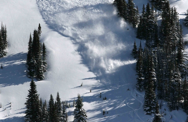
Avalanche danger in the West Kootenay backcountry is already heating up.
The Canadian Avalanche Centre in Revelstoke has already tagged the alpine and at the tree line as “high” in its avalanche potential for Tuesday through to Wednesday.
Below the tree line the risk is considered considerable for the next three days.
Heavy amounts of snowfall will accumulate over the next few days, the CAC reported Monday.
“This will likely create widespread avalanche activity all elevations,” said S. Werner with the CAC.
As a result, storm slabs may be touchy, run far and be destructive.
“This is a good time to stay out of avalanche terrain,” the report said.
Strong southwesterly winds will create new wind slabs on lee slopes and terrain features. These wind slabs may be found lower on the slope in unsuspected areas.
The CAC noted that observations were extremely limited at this time, and no new avalanches were reported from Sunday or Monday.
But the next few days will hold a different story, the report warned.
“I’d expect widespread avalanche activity,” said Werner. “They may react as storm slab instabilities with potentially triggering any weaknesses lower in the snow pack.”
Light snowfall amounts of up to 10 centimetres Monday night will take place in the southern part of the West Kootenay. Around 30 cm. of new snow has fallen last Friday and Saturday, significantly more at the south end of the West Kootenay.
Snow pack depths are likely in the 60-80 cm range at about 1,600 m. and about 130 cms at 2,000 m. In the upper snow pack, wind slab and storm snow instabilities exist around lee features and ridgelines.
There are also reports of a thin rain crust in the upper 50 cm. With the “Pineapple Express” on its way, the West Kootenay may see an abundance of new snow at higher elevations.
The accumulations could surpass the current total snow pack.


Comments