UPDATED: RDCK declares State of Local Emergency for Area B Friday

By Bruce Fuhr
The Regional District of Central Kootenay declared a State of Local Emergency in Area B of the Regional District Friday.
Bill Macpherson, Public Information Officer for the Emergency Operations Centre said in a press release, “the declaration pertains to a narrow strip of land at the bottom of the Goat River, bordered by Highway 21 to the west.”
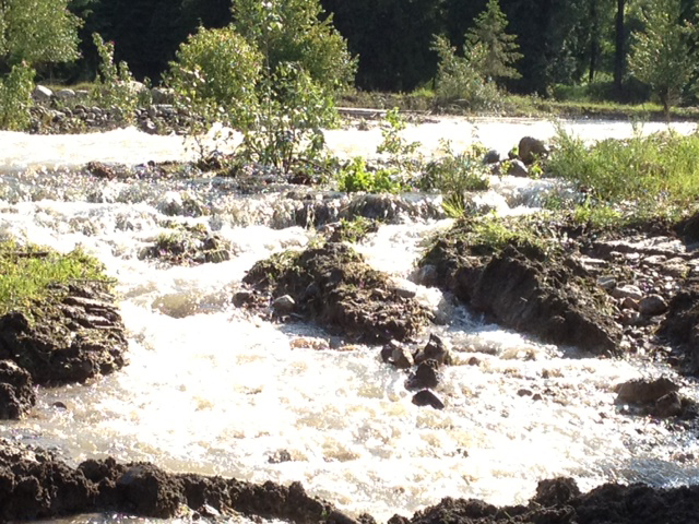
“A cool spring, recent heavy rains and a significant snowpack have contributed to flood conditions in localized areas throughout the RDCK,” Macpherson added.
Area B is located in and around Creston, including, Canyon, Erickson, Lister, Huscroft, Rykerts, Arrow Creek, Yahk, Goatfell, Kingsgate, Kitchener, Glenlily, Goat River Bottom and Lower Kootenay Band.
The Declaration of a State of Local Emergency enables remediation work to be done quickly in extraordinary conditions.
Earlier this week the RDCK declared a State of Local Emergency in Areas H and A of the Regional District of Central Kootenay.
Residents, particularly those living near streams, should use vigilance and be aware of the potential danger that exists.
Rivers, creeks and streams – and their banks – are dangerous throughout the spring runoff period. The heavy rains of the past 72 hours and the forecast for more precipitation in the coming days reinforces this danger.
Area H is located in the Slocan Valley and includes South Slocan, Crescent Valley, Slocan Park, Passmore, Winlaw, Red Mountain, Vallican, Perry Siding, Appledale, Hills, Summit Lake, Playmour Junction, Krestova, Brandon, Lemon Creek, Sandon, Rosebery and New Settlement.
Area A is the East Shore and includes Boswell, Sirdar, Sanca, Wynndel, Gray Creek, Kootenay Bay, Riondel, Twin Bays, Kuskanook, Pilot Bay and Crawford Bay.
East Shore gets hammered by Mother Nature; Crawford Bay residents evacuated, Highway 3A closed
It’s going to be a spring to forget for residents of the East Shore after days of rain finally caught up to the quiet community.
Wednesday evening a partial failure of a dyke on Crawford Creek forced the Regional District of Central Kootenay Emergency Operations Centre to issue an evacuation order affecting a number of residences and businesses downstream in the Crawford Bay area.
That evacuation order, affecting 16 residences and businesses in Crawford Bay, has since been rescinded, downgraded to an evacuation alert.
“An evacuation alert will remain in place for the time being, as work to shore up breaches in sections of the dike begins,” said Bill Macpherson, Public Information Officer for the Emergency Operations Centre in a written press release.
In the early hours of Thursday East Shore residents were hit with another major inconvenience when a mudslide near Gray Creek closed Highway 3A in both directions.
Macpherson said two pieces of heavy equipment are moving rock, clay and earth from a neighboring property and nearby stockpiles to fill the most serious breaches of the dyke on Crawford Creek while areas of water piping and overflow will be addressed to the best extent possible in the short term.
“These cumulative activities should decrease water flow and levels,” Macpherson said.
“Ongoing monitoring of the dike, particularly the 80-metre section of most concern, will occur throughout the night.”
Thursday morning, Highway 3A was closed in both directions 16 kilometers south of the Kootenay Bay Ferry Landing after a slide washed out the road.
Highway crews were busy all day and had the road open to alternating, single lane traffic by 6 p.m. according to the Drive BC website.
However, the road would be closed again Friday morning from 6 a.m. to noon to allow crews to make further repairs to the highway.
The highway closure gave students attending Crawford Bay School taht live south of Gray Creek an unexpected holiday.
When contacted Thursday evening regarding the status of other rivers in the RDCK, Macpherson said there are no other areas currently in the high-concern zone.
“There was a lack rain today so most of water levels have dropped a bit so things are looking better today,” Macpherson said.
“But there’s more rain expected in the forecast so we’re definitely not out of the woods yet.”
Other rivers on the RDCK watch include Moyie and Goat rivers in the East Kootenay and Salmo, Slocan, Redfish and Duhamel in the West Kootenay.


Comments