Search resumes; government explains email warning of potential slide

By Castlegar Source
The search for four people missing after a landslide Thursday in Johnsons Landing was resumed at 8 a.m., after geo-technologists determined that last night’s rain did not leave the site too unstable for the 70+ searchers, dogs and equipment.
A father, his two grown daughters, and a female tourist from Germany have been listed as missing.
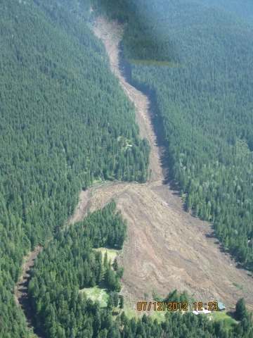
The slide area is 2,000 metres long, 100-200 metres wide and at least three to five metres deep, according to RDCK spokesman Bill Macpherson.
He said there’s also an excavator on site, but it’s not being used for the time being, as a painstaking grid-style search continues around two homes that were completely buried.
“They’re searching highest probability sites based on mapping, GPS and best information from community,” Macpherson explained.
“Access to site continues to be by boat and helicopter only.”
Meanwhile, Forests, Lands and Natural Resource Operations Minister Steve Thomson is defending the ministry against allegations they were notified of dangers on Gar Creek before Thursday’s slide happened.
A spokesman for the ministry, David Crebo, said a group of local residents were out hiking Wednesday, the day before the slide, and noticed alarming activity such as water surges around the creek.
The hikers sent an email to friends in the area, describing the unusual creek activity and suggesting the possibility of a flood or landslide.
An email conversation between residents ensued, which finally made its way into the email inbox of a retired government worker who lives in the area.
“That (retiree) then forwards the email string to a friend who is a current government worker, and it lands in his email inbox at around 9 a.m. Thursday,” Crebo said.
“Unfortunately, (the government worker to whom that email was sent) is a research hydrologist who is out in the field, doing his job, by the time the email arrives. He gets in at around 11:30 a.m. and logs on.
“At this point, he is oblivious and doesn’t realize the slide has happened, so he forwards the email string to an emergency worker.”
By then, unfortunately, the slide had already happened and it was too late for any sort of preventative intervention.
The email thread included these comments (names have been deleted):
As you may know, there were at least three, and possibly four, more surges of chocolate coloured water that came down Gar Creek over the course of yesterday (Wednesday, July 11).
Each of these brought down with it a significant number of logs and wood debris. Some of this formed an approximately 6 foot high log jam just below where the community intake used to be (which, by the way, has been COMPLETELY obliterated).
As soon as the log jam formed, gravel began to be deposited behind it. The entire level of the creekbed has now been raised at least 6 feet in that area. The entire creekbed has been made raw and is constantly being scoured and re-shaped.
Mom and I sat for about an hour on our trail just above the creek and watched it.
It was truly amazing to watch the speed with which radical shape-shifting was occurring: within ten minutes, in any given spot, the creekbed might be filled in a couple of feet and then the water would change course and it would be scoured out again.
One could constantly hear large rocks banging along the creekbed underwater.
The second of the day’s surges at around 9 a.m. deposited about three feet of debris over the upstream end of our driveway culvert, so now, virtually the entire creek in raging flood is flowing over and down our driveway for about 75 feet.
It is now impossible to get through, on foot even.
I have a good friend who lives near Nelson. For many years he was involved in Search and Rescue.
I described the situation and the behaviour of the creek to him and he expressed in no uncertain terms just how dangerous this type of situation can be.
He said that these surges of water and debris coming down the creek are very likely an indication of a large dam and building lake high up the mountain. He said that the surges could well be caused by small bits of the larger dam breaking off by water pressure and coming down.
I told him that we had thought that perhaps this was not happening, because the creek was still flowing well, but he said that water could be filling the lake, and we wouldn’t necessarily notice the difference in the flow rate down here.
If such a dam breaks loose, it’s anybody’s guess as to how high the wall of water and logs coming down the valley might be.
Crebo said anyone in the area witnessing such phenomena is urged to immediately contact emergency personnel.


Comments