Pack it up, pack it in: region’s snowpack punch fizzles into February

By Timothy Schafer Local Journalism Initiative Reporter
An atmospheric river has wreaked havoc on the region’s snowpack in 2024.
A series of storms — typically affecting Vancouver Island and the Lower Mainland — have disrupted winter, with atmospheric rovers sourced from tropical regions creating heavy rainfall with temperatures at or near record high temperatures, a “snow commentary” from the Province explained on Feb. 1.
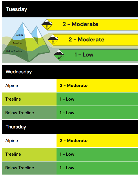
In the Kootenay backcountry, avalanche conditions were pegged at “moderate” by Avalanche Canada on Feb. 5, with “a few skier-controlled size one storm slab and dry loose avalanches reported from steep terrain on Monday.”
There was a bit of new snow with windy conditions Monday night, building fresh wind slabs in higher elevation terrain.
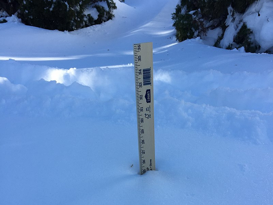
In all, there are reports of up to 20 centimetres of new snow accumulating over a crust at most elevations, but surface snow is likely moist or wet below 1,500 metres.
A layer of facets — and small surface hoar in some areas — is buried 30-60 cm deep, and a layer of facets sitting on a crust is buried 80-100 cm deep, the avalanche report for Nelson and region detailed on Monday night.
“While previous warming and subsequent cooling have likely helped to strengthen these layers, we will continue to monitor them for signs of reactivity,” the report stated.
Forecast snowfall amounts are uncertain.
But after a deep freeze with record low temperatures impacted the West Kootenay in mid-January, mountain snow has accumulated at a seasonal rate until recently.
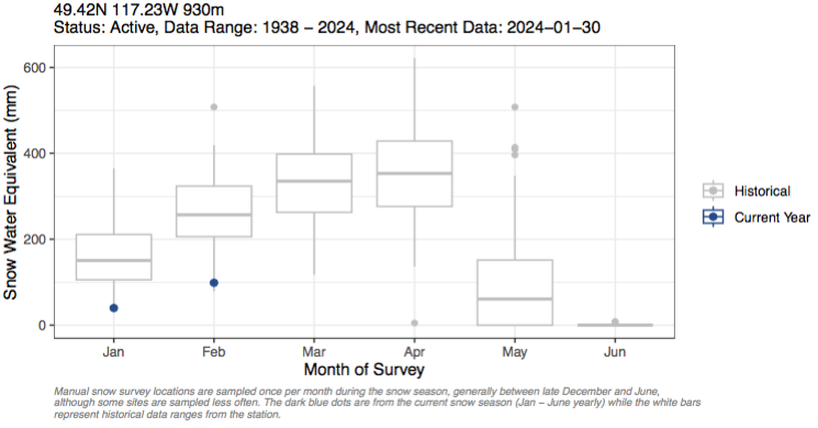
However, the majority of automated snow weather stations across the Kootenay-Boundary region are below the median snow for Feb. 1, with the provincial average of snow sitting at 66 per cent of median, an increase of one per cent from Jan. 1 (65 per cent).
In fact, a Provincial snow measuring station near Nelson measured its lowest total on record, with the Snow Survey and Water Supply Bulletin — published by the Ministry of Water, Land and Resource Stewardship — revealing the snowpack at the snow station southwest of Nelson was 25 per cent, the lowest in 63 years.
The most recent snowpack report for the West Kootenay region noted it was sitting at 57 per cent of normal, just above the average for the province (56 per cent), but is considered extremely low. Last year, the provincial average at this time was 82 per cent.
“There are early concerns for drought extending into the spring and summer with the extremely low snow pack throughout the province,” the report noted.
With around three months left for possible snow accumulation, the snow pack could still change significantly based on weather patterns through the remainder of the season.
The best indicator during the winter of potential water scarcity concerns for the upcoming summer are the snow basin indices.
“Upcoming challenges related to drought could include water supply issues, low groundwater levels, inadequate river levels for cultural needs, environmental flows, agricultural use, power generation, recreational use, wildfire risk, and more,” the report noted.
Weather watch
There is an El Niño advisory in effect for 2023-24, according to the Climate Prediction Center (CPC) at the U.S. National Weather Service.
El Niño is the warm phase of the El Niño-southern oscillation (ENSO), and it is expected to continue through the North American winter.
As the first El Niño winter season since 2018-19, El Niño is linked to warmer winters across British Columbia. During El Niño, snow packs tend to be lower than normal.
There is a greater likelihood of above normal temperatures for the West Kootenay and B.C. through March, according to seasonal weather forecasts.
However, precipitation is not showing any dominant trend of above normal or below normal precipitation.


Comments