Signs of improvement for West Kootenay info signs
By Andrew Zwicker
Ever actually stopped at one of those “Information areas” along the highways in the region? You know the ones I mean. The ones featured at highway pull outs, coated with outdated ads and feature a surprisingly square, seemingly scale-less, essentially useless series of connect-the-dot lines between community names?
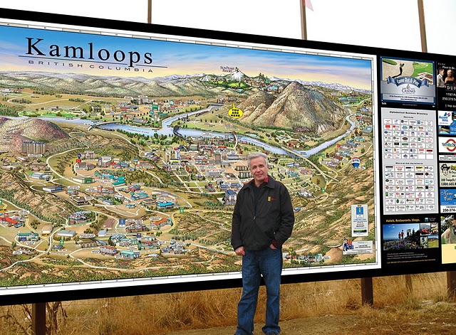
If you’ve ever wondered if anyone has found them useful, wonder no more. The West Kootenay is about to get groundbreaking new signage. Mountain Media out of Kelowna, following in the wake of a successful project for Kamloops, are setting out to install six of the informational pictorial maps around our region. They’ll be selling ad space along the borders of the sign as well as featuring businesses in the caricature. If nothing else however they’ll surely be an improvement over the existing signs and perhaps, as has happened in Kamloops, become tourist attractions themselves.
Put together and illustrated by Montreal-based artist Jean Louis Rheault, the West Kootenay signs are but the most recent products of a thirty year career in the pictorial map business that Rheault stumbled into a long time ago.
Having attended university and trained in translation and technical writing, a chance encounter with a friend and his childhood hobby of sketching conspired to frame out what would become Rheault’s calling.
“In 1980, I was helping out a friend of mine who was selling a cartoon map of Albany New York,” explained Rheault. “I hated the art work. I thought it looked really cheesy and goofy and that I could do a lot better. I did the selling for the advertising and over the course of a winter I really spent my time drawing and painting in a unique style, making my own map, going back to the older types of maps that were done in centuries before.”
Admittedly he wasn’t impressed with his first map: Albany redux. His second, however, a complicated mesh of buildings, landmarks, historical caricatures and embedded stories and secrets depicting Geneva, Switzerland, was a hit.
Like a haute-couture Where’s Waldo, Rheault’s maps featured caricatures of people like Mussolini, Caesar and Lenin, “who all spent time hanging out in Geneva,” he noted. One can spend a good chunk of time studying the map finding new pieces here and there they may have first missed.
Doing that type of research on a city or region he’s commissioned to depict has been one of the things Rheault has truly loved about a job he admits has had its ups and downs.
“The important thing I’m always looking for are those little details that you might not find in an official publication that people relate too. Like Rossland has a really nice main street that looks like an old western town, with cool old buildings. That kind of thing, or maybe some interesting history references, you know, that people can discover.”
Rheault works in a manner that is opposite to that of the typical cartographer.
“Most of the time when you do a map you’ll lay down a landscape, then roads, then put in the buildings and details. This is the opposite. I put in everything that is interesting first, flow the roads around them and then fill in the landscape in between.”
The typical process starts with the research, then talking to tourism and city officials to fully understand the area he’s working in. He then gets the basic aspect worked out, going from a regular map, tilting and rotating to find the aspect that will work best to include everything important. The scale is then morphed and warped to highlight the most important aspects. From there it goes back to the sales team. Depending on who they sign up to include businesses in the map, the final direction from sales sets him off on the home stretch of filling out the map.
In the early days, the map itself began as an ink sketch that would be filled in with watercolours. One of the issues in those earlier days was that, given the medium and the unsophisticated printing process, the maps were small. It wasn’t until thirty years later he was able to have one of his maps blown up to the 20 foot wide scale now seen in Kamloops and coming soon to the West Kootenay.
In the early 2000s, however, Rheault got caught up in the tech tsunami and made the switch to digital while working on the Okanagan Valley project in 2004. The move represented a leap forward technologically without sacrificing the hand drawn detail.
Utilizing a 27” drawing tablet, Rheault still draws each building, mountain, road, river and lake by hand–he just does it now with a stylus on a specialized table.
“The most difficult thing to do is a downtown area. If you look at the one I did of Montreal, for example, when you take a picture normally buildings are hidden by other buildings. The challenge is to space it out a bit so that you can see everything in the same image. That implies tweaking things, moving a bit to the right and a bit to the left something else and so on and so forth. That can be a real challenge.”
With the West Kootenay map expected to be erected in the Spring/Summer of 2012, Rheault is already looking ahead to his next project, capturing some of the tallest and most unique skyscrapers on the planet in the Middle East.
The seeming dream job of travelling the globe and transferring it to paint and pixel pictorial maps has begun to wear on him as “travel by airplane is not as glamorous as it once was.”
That disenchantment with security checks and being crammed into coach seats for trans-global flights are a little easier to take however when he’s got a particularly exciting destination on the other end.
“As a matter of fact, I’m in negotiation with people in the Middle East to do Dubai and other such places around there next. That’s something that is going to be coming up soon. I’m also doing something for Hawaii. That’s not going to be too bad. It makes the travel a little easier when it’s to Hawaii. More so than Albany New York for sure [laughs].”


Comments