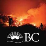
Provincial report warns of severe water repellency in West Kokanee Creek wildfire wake

By Timothy Schafer Local Journalism Initiative Reporter
A debris flow or flood could impact the land contained and below the summer’s West Kokanee Creek wildfire two years down the road, a Ministry of Forests report has revealed.
Despite the moderate soil burn severity due to the early August wildfire, severe water repellency was observed throughout the burn area, the report claimed, foretelling of potential hazards and risks such as downslope and downstream risks to life, property and infrastructure.
“Following a wildfire, the chances of soil erosion, landslides, and floods can increase,” the report noted. “This risk can be increased with intense rainfall or rapid snowmelt.”
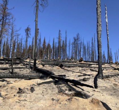
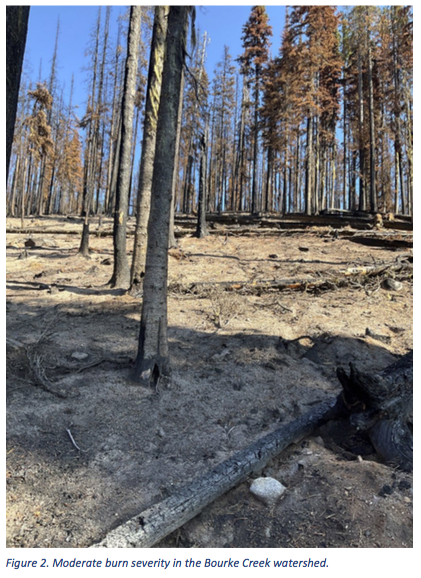
The vegetation burn severity for the West Kokanee Creek wildfire is mostly moderate with small patches of high and low burn severity, the report stated, but soil burn severity generally aligns with the vegetation burn severity.
As a result, debris flows and floods following wildfires can occur in summer following high-intensity rainfall on severely burned soils, illustrated by debris floods in 2023 on tributaries to Trozzo Creek following the 2021 fire.
The post-wildfire debris flow or flood hazard in Bourke Creek is rated as moderate, but the burned area is in the headwater area of a steep debris flow prone watershed.
“The strong and widespread water repellency observed throughout the burned area is somewhat mitigated by the needlecast, moderate soil burn severity and water storage capacity of the soil above the water repellent layer,” the report explained.
In the moderate soil burn severity areas, the forest floor was mostly consumed leaving grey ash. Many of the twigs and logs were charred, not consumed, and shallow live roots were noted at some plots.
“Despite the moderate soil burn severity, severe water repellency was observed throughout the burn area,” the report warned.
Two to three years after the wildfire the hazard is greatest due to increased snow accumulation, more rapid snowmelt, and higher groundwater levels in burned areas, and can persist for many years until revegetation occurs.
If a debris flow or flood were to occur on Bourke Creek — the wildfire burned 22 per cent of the watershed — the most likely scenario is that the culvert at the private road crossing would be plugged, and water and debris would overtop the private road and run through the property at 4163 Alpine Road perhaps impacting or flowing around several small guest cabins built along the channel, the report noted.
“Following the 1999 debris flow event, muddy water reportedly ran down the driveway at this site. The flow would then most likely cross Alpine Road and continue down Granger Road, with a low likelihood of impacting homes further downslope,” it read.
Hot summer
While the worst wildfire year on record gripped the province, the West Kokanee wildfire settled in 15 kilometres northeast of Nelson — on the ridgetop between Sitkum Creek and Kokanee Creek — on Aug. 7 and nine days later was declared under control by B.C. Wildfire Services.
Immediately adjacent to the 2017 Morley Creek fire, the West Kokanee fire burned 46 hectares but, because the fire was located in steep terrain above a densely rural populated area, a post wildfire natural hazards risk analysis was considered a high priority despite its small size.
The subsequent provincial report focused on the Bourke Creek watershed, despite small portions of the Morley Creek, Sitkum Creek and Kokanee Creek watersheds experiencing fire.
The Ministry of Forests conducts post wildfire analyses of the hazard areas that can affect residents.

Examining the risk
Severe wildfires result in the removal of the canopy and combustion of the organic material on the forest floor.
In some cases, the fire also may also cause changes to the soil structure and create a water repellent layer a few centimetres below the soil surface.
The removal of a canopy after a fire allows more precipitation to reach the ground and the loss of the forest floor reduces the water storage capacity in the soil, the report explained. Soil structural changes and water repellency reduce the infiltration capacity of the soil.
“During an intense rainstorm, these factors cause higher rates overland flow and more water to enter stream channels over a shorter period, increasing the likelihood of initiating a post-wildfire geohazard event,” it read. “If the organic layer has been completely consumed by the fire, the exposed mineral soil and ash is susceptible to erosion by overland flow, which may impact water quality and contribute to debris flow or flood bulking.”
Source: Ministry of Forests report
Burning questions
The Bourke Creek drainage is adjacent to the Morley Creek fire, where a post-wildfire debris flood occurred in 2019, two years after the fire.
“The West Kokanee burn severity is more moderate than the Morley Creek fire, yet widespread and strong water repellency was observed in both cases immediately after the fires,” the report stated.
During the field assessment the burned area from the 2017 Morley Creek fire was traversed and it was noted that vegetation regrowth in the high burn severity areas was minimal ( less than 25 per cent coverage).
“Patches of strong water repellency were observed at many locations,” the report said.
Go further
Click here to view the full report.


Comments