Trending up: West Kootenay snowpack percentage pedals upward as provincial prospects plummet

By Timothy Schafer Local Journalism Initiative Reporter
Cool and wet weather this spring has been able to reverse the doom and drought forecasts for the region on the snowpack front.
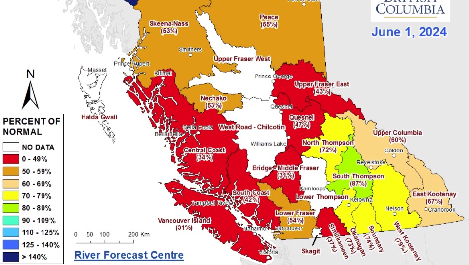
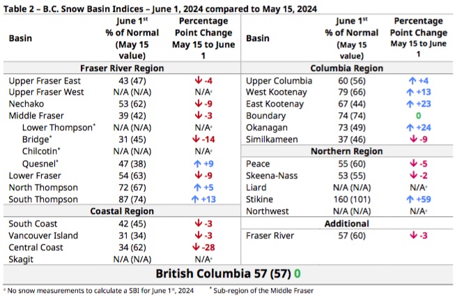
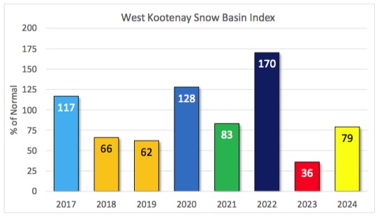
The West Kootenay regional snowpack has risen — according the June 1 Snow Survey and Water Supply Bulletin — to 79 per cent, jumping up from a concerning 66 per cent of normal in May.
According to the bulletin — produced by the B.C. Rivers Forecast Centre — the entire province is still unchanged and on the drier side of the ledger when it comes to the remaining snowpack lodged in watersheds (57 per cent on average).
In the West Kootenay, the snowpack has risen to the third highest basin percentage in the province, trailing only the South Thompson (87 per cent) region and Stikine (160 per cent).
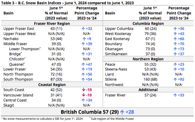
As of June 15, the provincial snowpack is extremely low, averaging 57 per cent of normal across B.C. Last year, the provincial average was 91 per cent.
“So far, 31 per cent of peak snowpack has melted this year, driven by low elevation melt in April and the significant heat event on May 9-12,” noted the report. “Last year, temperatures were much warmer and 43 per cent of the snowpack melted by this time.”
On average, 17 per cent of the seasonal snowpack melts by May 15. Last year, the June 1 provincial average was 29 per cent of normal as snowmelt rates throughout May were very rapid.
Despite most areas starting the snowmelt season with less snow than in 2023, lower rates of snowmelt at higher elevations this year have led to higher June 1 snow basin indices (SBI) values in most regions.
Even still, a below normal spring freshet flood hazard is expected to continue this season for most of the West Kootenay and Boundary region due to the low snowpack, but local flooding from extreme rainfall over the next six weeks is still a possibility.
“Low snowpack and seasonal runoff forecasts combined with warm seasonal weather forecasts and lingering impacts from on-going drought are creating significantly elevated drought hazards for this upcoming spring and summer,” the report explained.
Rain and snow
In general, precipitation was below normal in May for the Kootenay region as well as most of the province.
The onset of the snowmelt season has been mixed across the province. In low-to-mid elevations, particularly in plateau terrain in the B.C. Interior, early melt of a shallow snowpack has occurred and many of these areas are now snow-free.
“Higher elevation mountain snowpack has experienced a delay in melt due to cooler temperatures in late April, and some areas experienced additional late-season snow accumulation during recent unsettled weather periods,” the report explained.
Chance of weather
An El Niño advisory is still in effect, according to the Climate Prediction Center at the U.S. National Weather Service.
El Niño is the warm phase of the El Niño-Southern Oscillation (ENSO), meaning conditions trend toward warmer winters across B.C., with below normal snowpacks and earlier snowmelt.
The CPC forecasts an imminent transition to ENSO-neutral conditions.
“A La Niña Watch remains in effect from the CPC, with increasing odds of La Niña conditions developing in June-August (49 per cent chance) and likely continuing and impacting B.C. into fall-winter 2024-25 (next year),” noted the report. “La Niña winters are often relatively cool and wet, potentially causing delayed snowmelt if cooler temperatures persist.”
Seasonal weather forecasts from Environment and Climate Change Canada (ECCC) continue to indicate a moderate likelihood (40-95 per cent chance) of above normal temperatures across all of B.C. over the June to July period.
Current projections for May to July suggest above normal precipitation in portions of the southern Interior and Kootenay.
Spring has sprung
The International Kootenay Lake Board of Control (IKLBC) declared the “commencement of the spring rise” on Kootenay Lake as of April 16, the earliest it has occurred in seven years, and two weeks earlier than 2023. As a result, the spring freshet has begun.
Despite a low snowpack — currently sitting at 79 per cent of normal in the West Kootenay —through the first few months of 2024, FortisBC “remains in compliance with the IJC Order of Approval for Kootenay Lake and is prepared for the beginning of the spring freshet,” said Martin Suchy, Canadian secretary for the International Kootenay Lake Board of Control (IKLBC).
He said the late winter and early spring hydrological conditions in the Kootenay Lake watershed are shown to be below average this year.
Suchy said the U.S. Department of Agriculture’s Natural Resource Conservation Service (NRCS) is reporting similar percentages across the region, at 82 per cent of the 30-year period of record normal in the Kootenai Basin.
Measuring tape
At the time of declaration, the level of Kootenay Lake at Queen’s Bay was 1739.29 feet (530.14 metres), according to figures released from the board of control.
“Kootenay Lake inflow was 22,800 cubic feet per second and is forecast to continue increasing for the next month,” the IKLBC release noted.
Kootenay Lake at Queen’s Bay reached its minimum daily average elevation of 1,739.22 feet (530.11 meters) for the year on April 13-14, 2024.


Comments